
Suggested Traffic Patterns and Communications “Best Practice”
Follow this link for the Best Practices document
Traffic Patterns and Noise Abatement Procedures
Carson City Airport elevation is 4,705 feet (MSL). The traffic pattern altitude for Runway 9-27 is 1000 feet above the airfield elevation (TPA: 5,705 feet MSL). Aircraft landing Runway 9 use a right traffic pattern and Runway 27 is left traffic pattern. These traffic patterns ensure aircraft remain south of the airport when conducting training operations or arriving to the airport. The calm wind runway for Carson City Airport is runway 27.
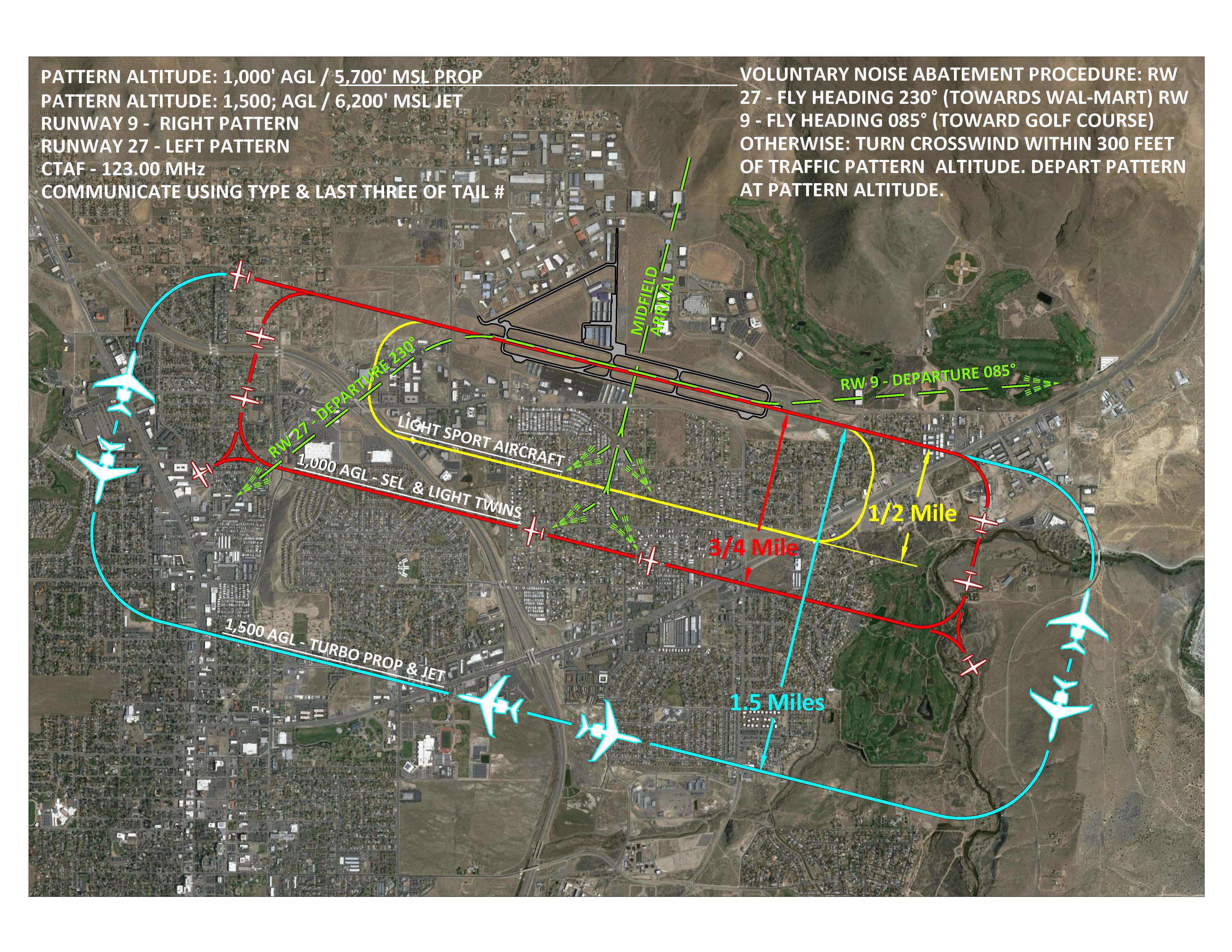
The Carson City Airport is a non-towered airport, uncontrolled airport as lies within Class G Airspace. Operations are conducted under visual flight rules (VFR) or under established Instrument Approach Procedures (IAP’s). All pilots are urged to use the CTAF at 123.0 and state their intentions in order to facilitate safety. Pilots are urged to tune to the AWOS frequency 119.925 to receive a current advisory.
Voluntary Noise Abatement
Runway 9: Aircraft are requested to turn to a heading of 085 after takeoff and maintain that heading until crossing Highway 50.
Runway 27: Aircraft are requested to turn to a heading of 230 after takeoff and maintain that heading until crossing Carson Street (old Highway 395). Runway use is dictated by wind conditions. Ideally, it is desirable for aircraft to land directly into the wind. Prevailing wind flow is from the west-southwest leading to a greater use of Runway 27.
NOTE: Runway 27 is the designated runway during calm wind conditions.
Instrument Approach Procedures
The airport is served by two instrument approach procedures (RNAV-GPS A) and RNAV-GPS RWY 27. A (SID) Standard Instrument Departure procedure is also provided for departing IFR traffic. Please consult a current NACO (federal) or Jeppesen approach plate.
For departing IFR traffic pilots may contact NORCAL Departure on the ground for IFR Clearance Delivery on 133.25 or by phone at (916) 361-0596. While airborne, NORCAL Approach can be contacted on 119.2, or Oakland Center on 127.95 Westbound, 125.75 East bound.